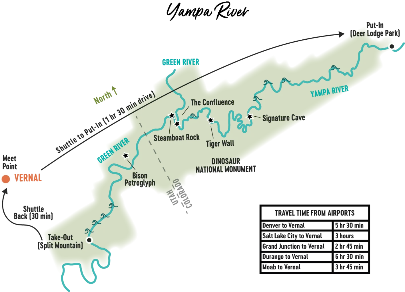
Yampa River Rafting Trip Map + River Log
Mile | Features and Highlights
| 0 | Deerlodge Park boat ramp and ranger station — river left. |
| 1.5 | Vale of Tears area — river right. |
| 2 | Disappointment Draw — river left. |
| 3 | Happy Hollow Canyon — river right. |
| 5 | Anderson Hole area — river right. Historic Stubs cabin. |
| 8 | Thanksgiving Gorge — river right. |
| 8.5 | Corral Springs Draw — river right. |
| 10 | Ponderosa Beach — river left. Ponderosa Pine are scattered throughout the canyon and are seen widely in this area. |
| 10.5 | Tepee Beach and Tepee Rapid. There’s a huge “hole” at the top of the rapid. |
| 12.5 | Haystack Rock — river right. Rock formations resembling haystacks formed in this area. |
| 13.5 | Bear Draw — river left. |
| 14 | Browns Draw — river left. |
| 17.5 | Little Joe Rapid. |
| 18 | Bower Draw — river right. |
| 19 | Dry Woman Canyon — river left. |
| 20.5 | Five Springs Draw and Five Springs Rapid. |
| 23 | Starvation Valley — river right. Big Joe Beach and Rapid. |
| 26.5 | Bull Canyon — river left. |
| 27 | Harding Hole Area. Wagon Wheel Point — hike from the river to the top of the canyon to overlook “Signature Cave” — river left. Ancient Fremont culture left behind artifacts found by the Post exploration party in the late 1920s. Many people wrote their names on the cave walls before it was designated a historical site. Pat Lynch left his mark here while living out his days in the canyon from the 1880s to 1917. |
| 29 | Mather’s Hole — river left. |
| 30.5 | Cleopatra’s Couch — river right. |
| 32.5 | Grand Overhang — river left. The sheer cliff wall stretches over the river creating a spectacular overhang. |
| 34.5 | Katy’s Nipple — river right. Burro Park — river left. |
| 35 | Mantle Ranch and Hell’s Canyon — private property, river left. Homestead ranch is still in operation. Hike up the cliff to the “Pat’s Cave” — river right. The view of the canyon is quite amazing. |
| 35.5 | 35.5 Mantle Cave — river left. Many ruins and artifacts are preserved here from the Fremont culture. Visitors welcome — pictures only please. |
| 37 | Red Rock Canyon — river left. |
| 38.5 | 38.5 Tiger Wall — river left. Minerals leached through the porous surface of the Weber sandstone create long black streaks down the rock face. Tradition calls for kissing the wall for luck before running Warm Springs Rapid. |
| 43 | Warm Springs Rapid. This legendary rapid has quite the notorious history. Formed overnight by a flash flood stemming from a side canyon. This rapid is extremely difficult to navigate with several hazards to avoid. |
| 45 | Box Elder Beach — river right. |
| 46 | Sand Canyon — river left. |
| 47 | Confluence with the Green River. End of the Yampa River. The muddy waters of the mighty Yampa flow into the Green river at this point. In spring, river speed picks up with the added water from the Yampa. |
| 47-49 | Echo Park and Steamboat Rock. The rock wall, spanning almost a mile, resembles a large steamboat. The river eventually makes a 180 degree turn to run along the other side of this magnificent formation. Echo Park boasts many attractions: Pool Creek rushing down to meet the Green, petroglyphs on cliffs visible from the many trails, inscriptions by the old hermit Pat Lynch, who wandered the area also called “Pat’s Hole.” Cool off in Whispering Cave — a deep cave that travels far back into the mountain. Several intricate petroglyphs are located further along from the cave. |
| 48-58 | Whirlpool Canyon. |
| 58-64 | Island Park — the river opens up into a large valley, meandering around a large group of islands. View the Uintah Mountains, Split Mountain, Ruple Ranch and the occasional moose. This is Utah-designated flat water. Life jackets are not required for those over 14. They are required if you are traveling in an inflatable kayak. |
| 64 | Rainbow Park boat ramp — life jackets are required from this point. |
| 65 | Enter Split Mountain Gorge. |
| 66 | Moonshine Rapid. |
| 67 | S.O.B. Rapid. |
| 67.5 | Schoolboy Rapid. |
| 70 | Natural warm spring flows into the river. A perfect stopping point to warm up from cool early season temperatures. |
| 70.5 | Inglesby Rapid. |
| 72 | Split Mountain boat ramp. Working dinosaur quarry, museum and gift shop located just minutes from the boat ramp. |
Plan Your Trip
FAQ
Yampa River Rafting
Got questions about how we roll on the Yampa? We've got answers!
Yampa FAQs
Camping & Dining
Yampa River Rafting
Find out what the camp situation is like, and what we're whipping up in the kitchen!
Camping & Dining
Itinerary
Yampa River Rafting
Check out our sample Itinerary for Yampa River rafting trips!
Itinerary
Map & River Log
Yampa River Rafting
A general map and detailed river log of the Yampa River in Dinosaur National Monument.
Map & River Log
Packing Guide
Yampa River Rafting
Wondering about proper river fashion, and what else to bring? Here's the complete list!
Packing Guide
Weather & Rapids
Yampa River Rafting
How's the weather and water in the Yampa River Canyon? Find out here!
Weather & Rapids

