
“If you really love something, you want to see all of it, not just the most beautiful parts of it.”
– Mike and Jenny Fiebig, River Advocates who spent five months paddling the entirety of the Colorado River
Like any river, the Colorado begins with a small trickle. Birthed from snowfall in the Wind River Mountains, its pure headwaters descend and grow massively, beginning at Grand Lake…
SPLAT! Let’s not get ahead of ourselves. The river undergoes three diversions within the initial 35-miles or so. Shadow Mountain Lake, Granby Lake, and Windy Gap Reservoir usurp a maximum of 310,000 acre-feet of water per year from the Colorado River. This redirected flow heads east to supply Coloradan homes and farms (USGS).
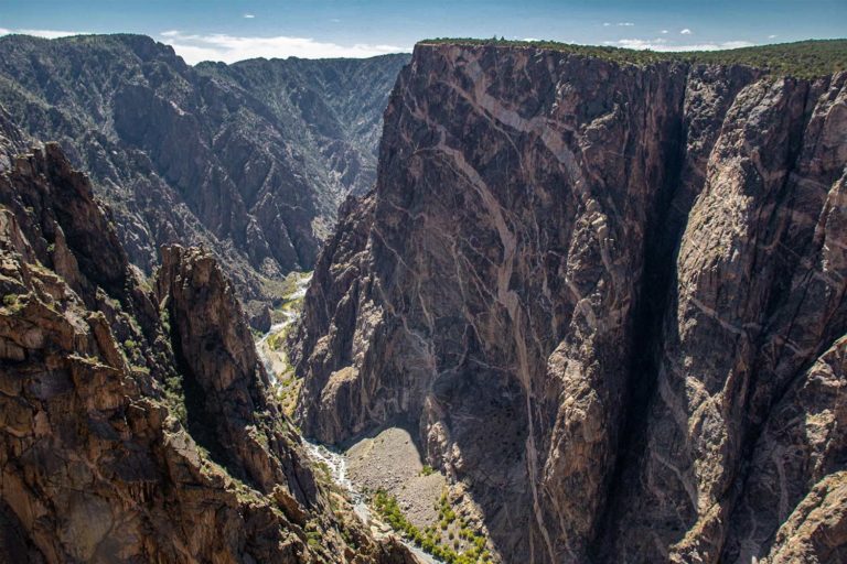
Then arrives Gore Canyon, the first notable erosion for river runners.
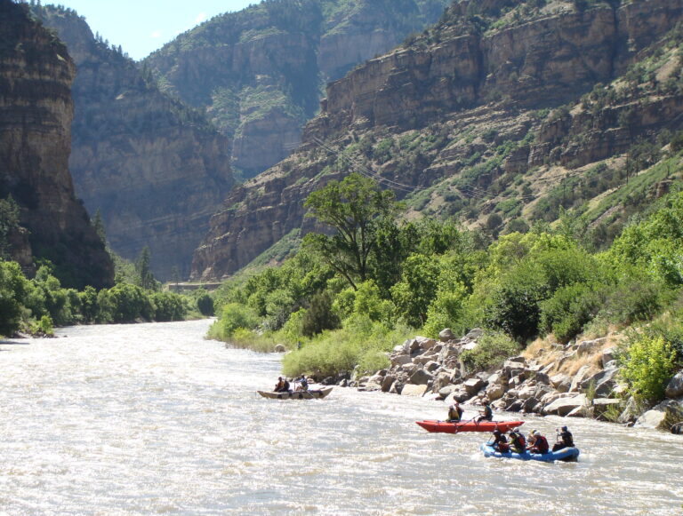
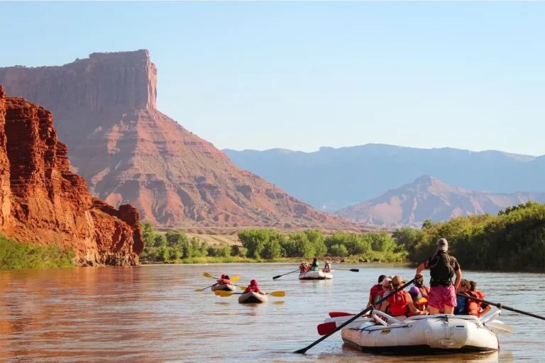
The Colorado River through Gore Canyon

Rafting just west of Kremmling, Colorado is no casual float. Considered a gnarly ride by even the most qualified river runners, Gore Canyon begins surprisingly flat. The rocky terrain then manifests a swath of boogies (rapids offering more smiles than worries), as well as hazardous and congested whitewater sections. The descent hits at a rate of about 43 feet per mile through continuous Class IV and V rapids, including a 12-foot waterfall (A Wet State). It is to say, one must paddle, and paddle hard.
Little and Lower Gore Canyons
After a massive whitewater section akin to taking a standardized test on the first day of school, the Little and Lower Gore Canyons are calmer. They slip through ranch land, forested cliffs, riverside campsites, and a few mild Class II–III rapids. From here, it’s possible to raft all the way to Dotsero, where the Colorado River meets Interstate 70.
Glenwood Canyon
Glenwood Canyon emerges alongside I-70, opening up to agricultural land and low, craggy bluffs. It twists and turns into three main sections for kayakers and rafters: Barrel Springs (often too low to run) and Shoshone and Grizzly Creek — 6-miles each of whitewater bliss. There’s also a whitewater park downstream of the Colorado and Roaring Fork Rivers’ confluence.
It’s About Dam Time for an Interlude
In Glenwood Canyon, there’s a dam some can perhaps appreciate.
Known as the Shoshone Generating Station, it protects the Colorado River’s flow by simultaneously generating power and diverting water along its natural course. Since 1902, instead of allocating the water eastward towards mass consumption, rights-holders have been legally binded to at least 1,250 cfs flowing past their intakes to Shoshone and other water users and ecosystems (KRCC).
Of the seventeen total dams and diversions running from the Colorado’s headwaters to the Gulf of México, Shoshone is an outlier. The hydropower generated along 1,450 river miles is often relentless, indispensable, and lights up California to Nebraska. Its watershed irrigates over 5 million acres of agricultural land. Constant diversions generate a 1.2 trillion dollar economy and hydrate around 40 million people, 30 sovereign tribes, and numerous protected areas (The Dirtbag Diaries).
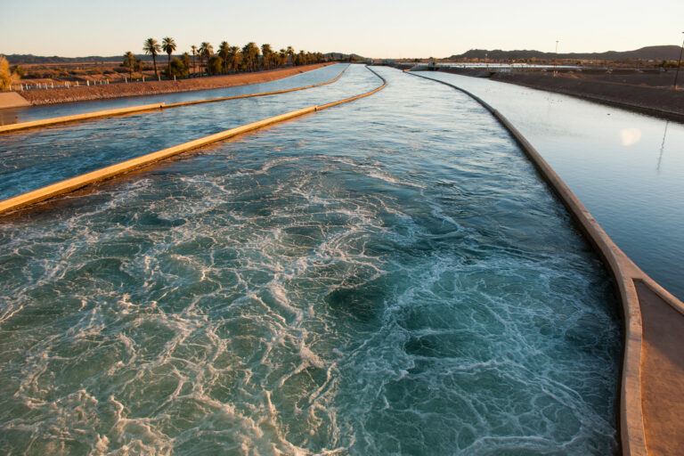
And with the All American Canal piping the bulk of Colorado’s water to the California agricultural industry, any of us who eat leafy greens in the winter are consuming Colorado River water.
The Colorado River through Horsethief and Ruby Canyons
Beyond Grand Junction, pines fade into cottonwoods on sandy soil. The river meets the Colorado Plateau and a whole lotta desert, sunburning the same black and red colors as the sunbaked sediment it brushes by.
In Horsethief and Ruby Canyons near Loma, Colorado, the river is calm with some Class I and II rapids. The scenery, on the other hand, is dramatic — black schist and pink and orange sandstone walls line the river, and canyons reveal natural rock arches and archaeological sites, before crossing the Utah border.
The Colorado River through Westwater Canyon
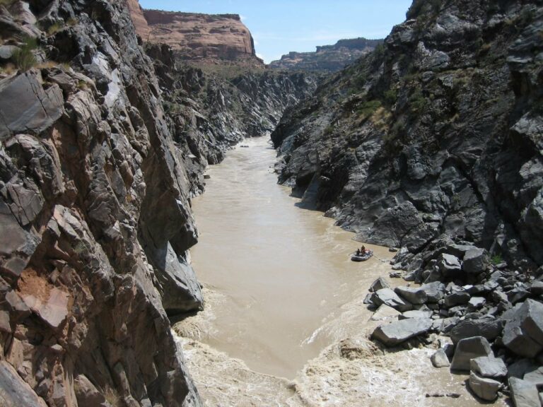
The narrower the canyon, the rowdier the ride. And Westwater is just that — 18-miles of Class I–IV whitewater wrapped in layers of black schist and pink granite beneath red-orange sandstone. Interestingly, the 1.7-billion-year-old schist is the same rock that is exposed in the deepest parts of the Grand Canyon (Bussard 24).
Cisco to Moab & The Fisher Towers
Between Cisco and Moab, the Dolores River joins the Colorado for 15-miles of peaceful, no frill water, perfect for bird watching.
Nearing Moab, the river meanders into a jaw-dropping landscape that many filmmakers deem cinematic gold. Referred to as Castle Valley, this stunning section of river runs the 20-mile length of Professor Valley. Textured red rock formations (the Fisher Towers) and snowcapped, purple and blue mountains (the La Sals) contrast in an unbelievably beautiful way. Many outfitters, including Mild to Wild, offer half and full-day trips along this mild, somewhat splashy stretch of the Colorado.
Cataract Canyon
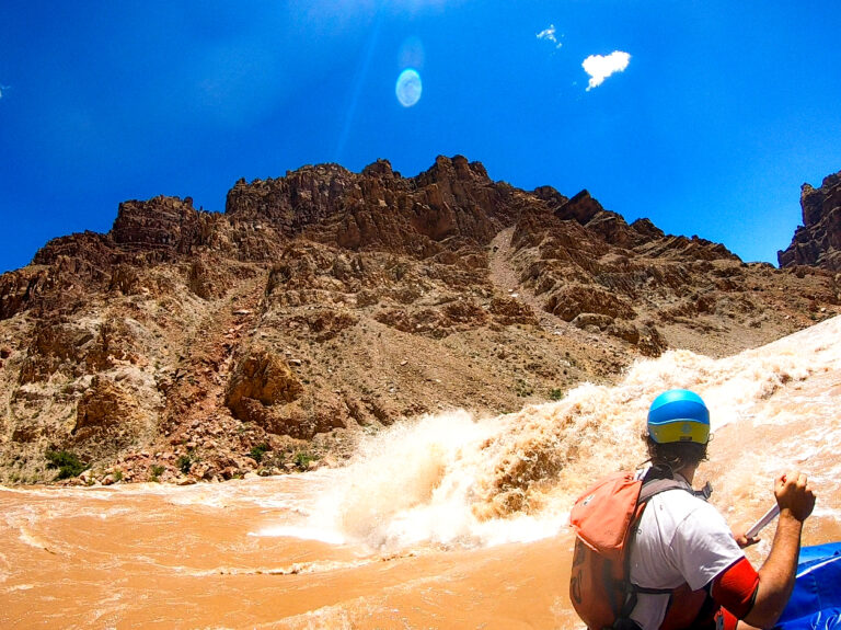
If Gore Canyon has the gnarliest waves, then Cataract Canyon has the wildest.
South of Moab, the Colorado River seeps into 50-miles of canyons in Canyonlands National Park. In addition to entering the park for free, the Colorado River unites with its biggest tributary, the Green River, then drops into the notorious Cataract Canyon.
Hundreds of miles downstream from any sizable dam, Cataract Canyon’s rapids reach 15, sometimes 25, or even 30-feet at flows of over 30,000 cubic feet per second. Giant S-Rig rafts are used for stability, but even with these, guides must pick and run their lines with extreme precision.
A Moment’s Pause for Lake Powell
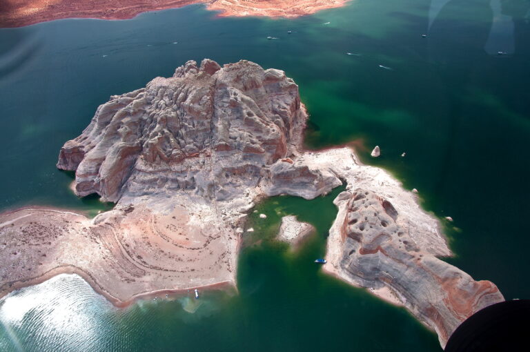
The end of Cataract Canyon lies beneath the sediment and still water of Lake Powell. In its prime, the giant reservoir engulfed more than 200-miles of the Colorado River, which included some of Cataract and all of Glen Canyon.
These days, water storage infrastructure is bottoming out with an overall drop in the Colorado River’s water level. Lake Powell, together with Lake Mead, store 80% of the watershed used by the seven Upper and Lower Basin states that ration the river’s waters. With predictions of 20 – 30% less water by 2050, there is growing concern that these reservoirs will no longer be able to generate power that millions of people rely on (The Dirtbag Diaries).
Alarmingly, Glen Canyon Dam’s current level, at 3,568 feet above sea level (measured in January, 2024), is significantly lower than optimal. Despite not yet reaching “dead pool” status, where power generation becomes impossible, it’s too low for comfort. Last year, the water level was 3,525 feet, marking one of the reservoir’s lowest levels since the 1960s. A wet winter replenished some lost water with above-average snowpack and record levels in some areas (InsideClimate News).
Should the level drop to 3,490 feet, the water will be insufficient to power the turbines used for electricity generation. At 3,370 feet, it would reach “dead pool” status, and the water would be too low to flow downstream. This result would be catastrophic for communities south of the dam (InsideClimate News).
There’s More Water on Paper Than There is in the River

How can Lake Powell and Lake Mead be edging so close to record-low water levels? The 1922 Colorado Compact is to blame.
When water was originally allocated under this age-old agreement, the river was going through an unusually wet period. After 1930, the river returned to its natural state that had been characteristic of the 1800s. Today, there’s 30% less water in the river than when the Compact was written, and the West’s population has grown exponentially (The Dirtbag Diaries).
Humans, it turns out, have been consuming more water than is the natural supply of the watershed for the last 20-years. And how did we get away with this for so long? The same way one can quit their job and backpack from Peru to Cambodia: savings, which in Colorado River talk, translates to Lake Powell and Lake Mead.
With savings running out, little income, and continued spending, the river and the ecosystems it sustains are desperate for a solution. While reduced reservoir levels have allowed the river in Lower Cataract Canyon to reclaim about 30-miles, give or take yearly fluctuations, losing Lake Powell would be devastating.
The Colorado River through the Grand Canyon
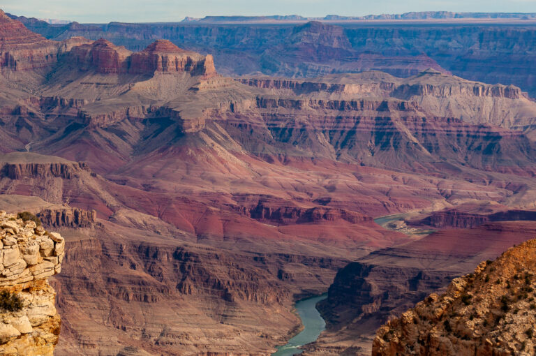
Deep under Lake Powell, the river crosses the border into the third state claiming rights to its water: Arizona. Below the Colorado River’s second largest dam, Glen Canyon, which creates Lake Powell, lucky river runners put in at Lee’s Ferry for Grand Canyon trips.
With over 200-miles of river and 1.5 billion years of the Earth’s history, rising to 6,000 feet, the Grand Canyon takes about two weeks to raft. The many rapids are well-known, large, and entertaining. The water that is released from the dam, however, is a freezing 46°F, requiring wetsuits and splash jackets, even during the hottest summer months.
The take-out for most rafters is Diamond Creek, from where the canyon continues its grandeur for another 50-miles. It ends at the Grand Wash Cliffs, where Lake Mead swallows its current.
Black Canyon
Right at the start of Black Canyon sits the first and largest dam ever constructed on the Colorado River — the Hoover Dam that forms Lake Mead.
These final 30-miles of river, still open to non-motorized crafts, offer gateways to beaches, lost coves, hot springs, and flat water. For the journey to Lake Mohave Reservoir, kayaks and canoes fare far better than rafts.
The Colorado River is a Reverse Hourglass

Unlike other rivers, the Colorado no longer reaches the sea. Rather, it’s like a reverse hourglass. It starts small, expands, then begins to die starting at Lake Powell.
On top of giving life to seven states and Northwest México, it forms the Arizona-Nevada and Arizona-California borders. Of the 17-plus dams and diversions on the river, eight of them are between the Hoover Dam and the Mexican border, built to sustain massive agricultural production and life in the desert.
Beyond Black Canyon, the river slowly moves past the palm trees and RV Parks of Lake Havasu and the Headgate Rock Dam, where water is diverted to farms on the Colorado River Indian Reservation. It continues to the Palo Verde Diversion Dam, sending water to citrus farms in Imperial and River Counties, California, then to Imperial Diversion, where water is allocated to the US’s most productive farming region: Imperial Valley, California.
Despite the river crossing into México and providing life sustaining water, the US excluded México from water rights until 1944. Finally, a treaty allocating 1.5 million acre-feet of water per year to México was ratified. In 1960, per the agreement, the Davis Dam was built to store water for México in Lake Mohave (The Dirtbag Diaries).
The Heart of Who We Are as a People
The legacy of exclusion continues today within the US’s own borders. The voices of around 30 sovereign tribes with water rights entitling them to 25% ownership, unfortunately, do not have seats at tables where decisions about water allocation are made. Though entities like the Jicarilla Apache Nation have been pushing hard for change at the House of Representatives, such as in the 2021 Colorado River Drought Conditions Hearing, lack of representation persists (The Dirtbag Diaries).
“We don’t want to take anything away from anybody, we absolutely understand what that feels like in terms of having something taken away, not only the land and the water, but your very identity and the heart of who you are as a people.”
– Mr. Daryl Vigil, Jicarilla Apache Water Administrator and Co-Facilitator
Hope at the Delta
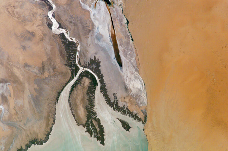
Long ago, the Colorado River flowed through México for 100-miles or so, surrounded by lush jungles and wetlands. Dolphins, jaguars, and diverse bird species roamed what we now call the Mexicali Valley (CounterPunch).
Today, there are bridges crossing dry riverbeds. The waterway trickles like its headwaters, except through industrial impoundments rather than pure, high alpine terrain.
We could still choose a different destiny: Innovation in new technology that uses less water, tribes’ enacting their ideas and solutions, and strong federal leadership enforcing reductions in water use are actions we have to take now to preserve a waterway that gives us so much.